October 2011
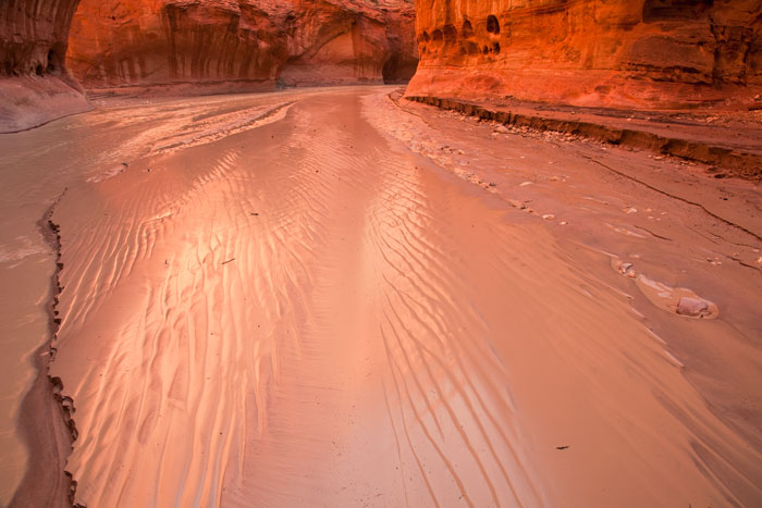
Paria Canyon Wilderness, Vermilion Cliffs National Monument, AZ, USA
Canon 5D MkII & EF 24-105mm f/4L IS USM, 0.3s f/16 ISO400 @24mm
No matter the list in which you look, the trek through the Paria Canyon always appears as one of the best hikes in the world. And with good reason. This wonderful 39 mile long hike is fully spent within the narrow canyon dug by the Paria River across the most colorful sandstone you are likely to find anywhere, with huge vertical walls on both sides that are always several times higher than the canyon width. You very quickly find yourself completely removed from the outside world as mile after mile of narrow canyon goes by without ever being even close to having a glimpse of what lies above the cliffs. You can only gain some perspective by looking forward until the next turn of the river, or backwards until the previous turn, but never to the sides. It feels like being in a parallel world with only two dimensions (vertical and longitudinal), as the canyon is never wider than 100 feet (and most of the time much narrower), and the nearly complete lack of vegetation and sounds also seems to freeze time.
There is no path whatsoever in this trek. You just walk along the riverbed of the Paria, which most of the year is not a river but a creek, and sometimes not even that. However, the Paria River watershed covers more than 450 square miles, which seems surprising for such a small river. But when the short but strong summer thunderstorms fall in this area, all the water is quickly channeled towards the river, which can in very short time grow into a muddy angry torrent of huge proportions. These floods are the ones responsible for the carving of the canyon, leaving logs stranded within cracks in the canyon walls many feet above the ground.
I've never hiked the canyon from one side to the other, although I hope to do so one day. Many years ago I camped for two nights around mile #9, past the confluence with Buckskin Gulch, in what is regarded by many as the most beautiful area of the trek. No water flowed through the canyon then, which was completely covered by footprints on the mostly dry mud, although a quota system restricts the number of people that can enter the canyon each day. I hold very fond memories of those days, and I've always wanted to return. But this time I did it only for the day (although it was an extremely long and demanding day) as it had rained a lot on the previous days and the river was running quite high. This made for a very demanding trek, as I had to cross the thigh high river hundreds of times and even walk along it for several minutes non stop in the narrower parts of the canyon, where the water covered it from side to side.
I departed 30 minutes before sunrise and needed four hours to get the confluence (at mile #7), but then I had the extremely beautiful miles that follow only for myself, as I did not find any other soul in the whole day. After the confluence the canyon widens a little bit while the lateral walls grow even more, reaching enormous size. In this area the canyon was wide enough for the river to leave beautiful mud on its banks, covered with beautiful ripples and no footprints at all. It was a virgin photographic paradise where I took image after image taking advantage of the reflecting light turning the canyon walls into fire. This link takes you to another photo of that day. I set my alarm clock at four hours before sunset, and after leaving the area with regret, spent every available minute of daylight hiking upstream to my tent, where I got completely exhausted but with the feeling of having experienced the beauty of the canyon in nearly unbeatable conditions.